
Make a donation
Gear up for your next adventure:
As an Amazon Associate, this site earns from qualifying purchases at no extra cost to you.
Wetaskiwin topographic map
Click on the map to display elevation.
Make a donation
Gear up for your next adventure:
As an Amazon Associate, this site earns from qualifying purchases at no extra cost to you.
Wetaskiwin
The city lies at an elevation of 760 m (2,490 ft). Coal Lake, a reservoir developed on the Battle River is located immediately east of the city, and other nearby waterways include Pipestone Creek, Bigstone Creek, Bittern Lake and Bearhills Lake.
Make a donation
Gear up for your next adventure:
As an Amazon Associate, this site earns from qualifying purchases at no extra cost to you.
About this map
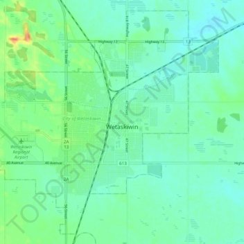
Name: Wetaskiwin topographic map, elevation, terrain.
Location: Wetaskiwin, Alberta, Canada (52.94288 -113.42641 52.99623 -113.32960)
Average elevation: 760 m
Minimum elevation: 749 m
Maximum elevation: 789 m
Wetaskiwin trails, hiking, mountain biking, running and outdoor activities
Make a donation
Gear up for your next adventure:
As an Amazon Associate, this site earns from qualifying purchases at no extra cost to you.
Other topographic maps
Click on a map to view its topography, its elevation and its terrain.