Geolocate

Harwich topographic map

Click on the map to display elevation.

About this map

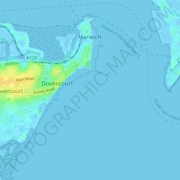
Name: Harwich topographic map, elevation, terrain.

Location: Harwich, Dovercourt, Tendring, Essex, England, United Kingdom (51.91514 1.22976 51.94970 1.29659)

Average elevation: 1 m

Minimum elevation: -2 m

Maximum elevation: 22 m

Other topographic maps

Click on a map to view its topography, its elevation and its terrain.

Clacton-on-Sea

United Kingdom > England > Essex > Tendring

Average elevation: 7 m

Dovercourt

United Kingdom > England > Essex > Tendring

Average elevation: 4 m

Walton-on-the-Naze

United Kingdom > England > Essex > Tendring

Average elevation: 3 m

Frinton-on-Sea

United Kingdom > England > Essex > Tendring

Average elevation: 5 m

Dovercourt

United Kingdom > England > Essex > Tendring

Average elevation: 4 m

Clacton-on-Sea

United Kingdom > England > Essex > Tendring

Average elevation: 7 m

Clacton-on-Sea

United Kingdom > England > Essex > Tendring

Average elevation: 7 m

Frinton-on-Sea

United Kingdom > England > Essex > Tendring

Average elevation: 5 m

Gear up for your next adventure:

🧢Outdoor Visor - Breathable visor for sunny hikes
🌡️Emergency Mylar Blankets - Compact thermal protection for unexpected nights outdoors
🧭GPS Handheld Device - Reliable GPS navigation for outdoor adventures
🥾Hiking Boots - Sturdy boots providing ankle support and traction on rugged trails
🥾Trail Running Boots - Durable shoes designed for trail running

As an Amazon Associate, this site earns from qualifying purchases at no extra cost to you.