Geolocate

Cawag topographic map

Click on the map to display elevation.

About this map

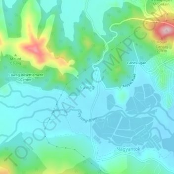
Name: Cawag topographic map, elevation, terrain.

Location: Cawag, Subic, Zambales, Central Luzon, 2209, Philippines (14.85518 120.16461 14.89518 120.20461)

Average elevation: 58 m

Minimum elevation: -1 m

Maximum elevation: 287 m

Other topographic maps

Click on a map to view its topography, its elevation and its terrain.

Acid Lake

Philippines > Zambales > Subic

Average elevation: 390 m

Mangan-vaca River

Philippines > Zambales > Subic > Ilwas

Average elevation: 33 m

Gear up for your next adventure:

🥤Collapsible Travel Cup - Saves space and weight in your mess kit
🥾Hiking Leggings - Comfortable leggings for outdoor activities
🧥Softshell Hiking Jacket - The perfect balance of wind protection and breathability
🚲MTB Frame Bag - Carry tools and maps directly on your bicycle frame
🥾Trail Hiking Socks - Comfortable socks to prevent blisters and fatigue

As an Amazon Associate, this site earns from qualifying purchases at no extra cost to you.