Geolocate

Tregeiriog topographic map

Click on the map to display elevation.

About this map

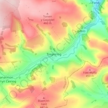
Name: Tregeiriog topographic map, elevation, terrain.

Location: Tregeiriog, Wrexham, Wales, LL20 7HY, United Kingdom (52.87564 -3.24408 52.91564 -3.20408)

Average elevation: 355 m

Minimum elevation: 200 m

Maximum elevation: 489 m

Gear up for your next adventure:

🧴Insect Repellent - Protect yourself from bugs during outdoor adventures
🪜Heavy Duty Carabiners - Multi-use clips for securing gear to your backpack
🧭Orienteering Kit - Tools for map reading and navigation in the wild
🥾Mountain Trail Shoes - High-traction shoes for mountain trails
🧣Merino Neck Gaiter - Protects against wind, sun, and cold at high altitudes

As an Amazon Associate, this site earns from qualifying purchases at no extra cost to you.