
Laguardia topographic map
Interactive map
Click on the map to display elevation.
About this map
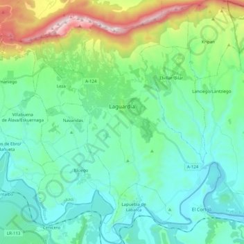
Name: Laguardia topographic map, elevation, terrain.
Average elevation: 592 m
Minimum elevation: 369 m
Maximum elevation: 1,385 m
Other topographic maps
Click on a map to view its topography, its elevation and its terrain.
Labastida/Bastida
Spain > Autonomous Community of the Basque Country > Arabako Errioxa/Rioja Alavesa
Labastida/Bastida, Arabako Errioxa/Rioja Alavesa, Álava, Autonomous Community of the Basque Country, 01330, Spain
Average elevation: 611 m
Salinillas de Buradón/Gatzaga Buradon
Spain > Autonomous Community of the Basque Country > Arabako Errioxa/Rioja Alavesa > Labastida/Bastida
Salinillas de Buradón/Gatzaga Buradon, Labastida/Bastida, Arabako Errioxa/Rioja Alavesa, Álava, Autonomous Community of the Basque Country, Spain
Average elevation: 599 m
Oyón/Oion
Spain > Autonomous Community of the Basque Country > Arabako Errioxa/Rioja Alavesa
Oyón/Oion, Arabako Errioxa/Rioja Alavesa, Álava, Autonomous Community of the Basque Country, 01320, Spain
Average elevation: 572 m