Geolocate

Labastida/Bastida topographic map

Click on the map to display elevation.

Labastida/Bastida

The town is at 529m altitude, and is positioned between the River Ebro and the Sierra de Toloño mountain range.

Wikipedia (CC-BY-SA 3.0)

About this map

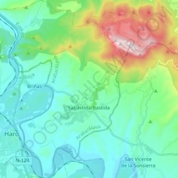
Name: Labastida/Bastida topographic map, elevation, terrain.

Location: Labastida/Bastida, Arabako Errioxa/Rioja Alavesa, Álava, Autonomous Community of the Basque Country, 01330, Spain (42.55424 -2.85929 42.64518 -2.76566)

Average elevation: 611 m

Minimum elevation: 423 m

Maximum elevation: 1,252 m

Gear up for your next adventure:

🥾Mountain Hiking Shoes - Shoes with superior grip for mountainous terrain
🥾Waterproof Trail Shoes - Shoes designed to handle wet terrain
🧦Merino Wool Socks - Moisture-wicking comfort for long-distance hiking
🥾Hiking Gaiters - Protect legs and shoes from mud, snow, and debris
👟Trail Running Shoes - Agile footwear for fast-paced topographic exploration

As an Amazon Associate, this site earns from qualifying purchases at no extra cost to you.