
Gaurikund topographic map
Interactive map
Click on the map to display elevation.
About this map
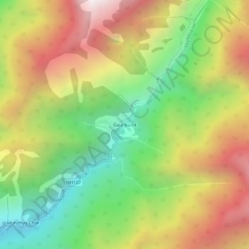
Name: Gaurikund topographic map, elevation, terrain.
Location: Gaurikund, Ukhimath, Rudraprayag, Uttarakhand, India (30.63340 79.00682 30.67340 79.04682)
Average elevation: 2,589 m
Minimum elevation: 1,749 m
Maximum elevation: 3,559 m
Other topographic maps
Click on a map to view its topography, its elevation and its terrain.
Lake Vasuki Tal
India > Uttarakhand > Ukhimath > Kedarnath
Lake Vasuki Tal, Kedarnath, Ukhimath, Rudraprayag District, Uttarakhand, India
Average elevation: 4,303 m
Chorabari Glacier
India > Uttarakhand > Ukhimath > Kedarnath
Chorabari Glacier, Kedarnath, Ukhimath, Rudraprayag District, Uttarakhand, India
Average elevation: 5,011 m
Mansuna
India > Uttarakhand > Ukhimath
Mansuna, Ukhimath, Rudraprayag District, Uttarakhand, 246469, India
Average elevation: 1,653 m
Uthind
India > Uttarakhand > Ukhimath
Uthind, Ukhimath, Rudraprayag District, Uttarakhand, 246419, India
Average elevation: 1,601 m
Khunnu
India > Uttarakhand > Ukhimath
Khunnu, Ukhimath, Rudraprayag District, Uttarakhand, India
Average elevation: 1,841 m
Kedarnath
India > Uttarakhand > Ukhimath
Kedarnath, Ukhimath, Rudraprayag District, Uttarakhand, India
Average elevation: 4,219 m
Sersi
India > Uttarakhand > Ukhimath > Sersi
Sersi, Ukhimath, Rudraprayag, Uttarakhand, 246471, India
Average elevation: 1,942 m
Chopta Chatti
India > Uttarakhand > Ukhimath > Chopta Chatti
Chopta Chatti, Ukhimath, Rudraprayag, Uttarakhand, India
Average elevation: 2,759 m
Sonprayag
India > Uttarakhand > Ukhimath
Sonprayag, Ukhimath, Rudraprayag, Uttarakhand, 246471, India
Average elevation: 2,053 m
Guptkashi
India > Uttarakhand > Ukhimath
Guptkashi, Ukhimath, Rudraprayag District, Uttarakhand, 246439, India
Average elevation: 1,449 m