Geolocate

Partille kommun topographic map

Click on the map to display elevation.

About this map

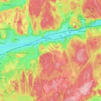
Name: Partille kommun topographic map, elevation, terrain.

Location: Partille kommun, Västra Götaland County, Sweden (57.68221 12.05413 57.77527 12.22574)

Average elevation: 87 m

Minimum elevation: 2 m

Maximum elevation: 160 m

Other topographic maps

Click on a map to view its topography, its elevation and its terrain.

Bolstad

Sweden > Västra Götaland County

Average elevation: 55 m

Ed

Sweden > Västra Götaland County

Average elevation: 155 m

Ljungskile

Sweden > Västra Götaland County

Average elevation: 53 m

Uddevalla

Sweden > Västra Götaland County

Average elevation: 71 m

Heestrand

Sweden > Västra Götaland County

Average elevation: 11 m

Strömstad

Sweden > Västra Götaland County

Average elevation: 21 m

Trollhättan

Sweden > Västra Götaland County

Average elevation: 58 m

Mariestad

Sweden > Västra Götaland County

Average elevation: 59 m

Jonsered

Sweden > Västra Götaland County

Average elevation: 73 m

Henå

Sweden > Västra Götaland County

Average elevation: 158 m

Gear up for your next adventure:

🪜Heavy Duty Carabiners - Multi-use clips for securing gear to your backpack
🧭GPS Outdoor Watch - Smart watch for navigation and fitness tracking in nature
🧰Survival Kit - Essential gear for emergencies in the wilderness
🥤Collapsible Travel Cup - Saves space and weight in your mess kit
🛶Waterproof Dry Bags - Keep electronics and clothes dry during river crossings

As an Amazon Associate, this site earns from qualifying purchases at no extra cost to you.