Geolocate

Ridgeland topographic map

Click on the map to display elevation.

About this map

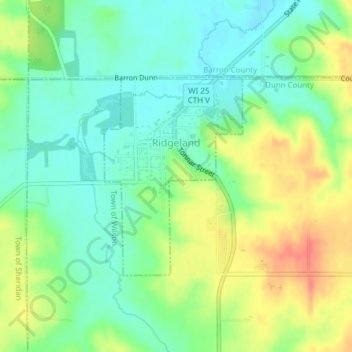
Name: Ridgeland topographic map, elevation, terrain.

Location: Ridgeland, Dunn County, Wisconsin, United States (45.19330 -91.90338 45.20848 -91.88826)

Average elevation: 346 m

Minimum elevation: 324 m

Maximum elevation: 380 m

Other topographic maps

Click on a map to view its topography, its elevation and its terrain.

Cedar Falls

United States > Wisconsin > Dunn County

Average elevation: 274 m

Mount Fuji

United States > Wisconsin > Dunn County

Average elevation: 313 m

Mount Fuji

United States > Wisconsin > Dunn County

Average elevation: 313 m

Graytown

United States > Wisconsin > Dunn County

Average elevation: 344 m

Canary Island

United States > Wisconsin > Dunn County > Menomonie

Average elevation: 262 m

Gear up for your next adventure:

🔭Compact Monocular - One-handed bird watching and trail spotting
🔭Outdoor Binoculars - Lightweight binoculars for birdwatching and hiking
🥾Durable Hiking Shoes - Long-lasting shoes for frequent hiking
🛏️Sleeping Bag - Warm and compact sleeping bags for outdoor camping
🧥Waterproof Pants - Keep dry during rainy hiking conditions

As an Amazon Associate, this site earns from qualifying purchases at no extra cost to you.