
Tay Valley topographic map
Click on the map to display elevation.
About this map
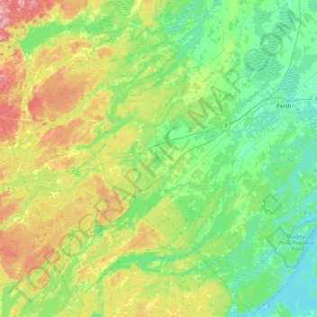
Name: Tay Valley topographic map, elevation, terrain.
Location: Tay Valley, Lanark County, Eastern Ontario, Ontario, Canada (44.70290 -76.60871 44.99595 -76.18841)
Average elevation: 169 m
Minimum elevation: 120 m
Maximum elevation: 273 m
Lanark County trails, hiking, mountain biking, running and outdoor activities
Other topographic maps
Click on a map to view its topography, its elevation and its terrain.
Port Elmsley
Canada > Ontario > Lanark County > Drummond-North Elmsley > Port Elmsley
Average elevation: 131 m