Make a donation
Gear up for your next adventure:
As an Amazon Associate, this site earns from qualifying purchases at no extra cost to you.
Shirak topographic map
Click on the map to display elevation.
Make a donation
Gear up for your next adventure:
As an Amazon Associate, this site earns from qualifying purchases at no extra cost to you.
About this map
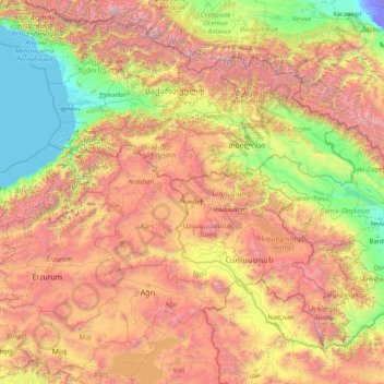
Name: Shirak topographic map, elevation, terrain.
Location: Shirak, Armenia (38.31859 41.24035 43.51859 46.44035)
Average elevation: 1,449 m
Minimum elevation: -22 m
Maximum elevation: 5,628 m
Make a donation
Gear up for your next adventure:
As an Amazon Associate, this site earns from qualifying purchases at no extra cost to you.
Other topographic maps
Click on a map to view its topography, its elevation and its terrain.
Make a donation
Gear up for your next adventure:
As an Amazon Associate, this site earns from qualifying purchases at no extra cost to you.
Lake Sevan
Armenia > Gegharkunik Province
Lake Sevan (Armenian: Սևանա լիճ, romanized: Sevana lich) is the largest body of water in both Armenia and the Caucasus region. It is one of the largest freshwater high-altitude (alpine) lakes in Eurasia. The lake is situated in Gegharkunik Province, at an altitude of 1,900 m (6,234 ft) above sea level.…
Average elevation: 2,025 m
Make a donation
Gear up for your next adventure:
As an Amazon Associate, this site earns from qualifying purchases at no extra cost to you.
Make a donation
Gear up for your next adventure:
As an Amazon Associate, this site earns from qualifying purchases at no extra cost to you.
Make a donation
Gear up for your next adventure:
As an Amazon Associate, this site earns from qualifying purchases at no extra cost to you.
Make a donation
Gear up for your next adventure:
As an Amazon Associate, this site earns from qualifying purchases at no extra cost to you.
Sisian
Sisian (Armenian: Սիսիան [sisˈjɑn]) is a town and the centre of the Sisian Municipality of the Syunik Province in southern Armenia. It is located on both banks of the Vorotan River, at an altitude of 1600 m above sea level, 6 km south of the Yerevan-Meghri highway, at a road distance of 217 km…
Average elevation: 1,642 m
Make a donation
Gear up for your next adventure:
As an Amazon Associate, this site earns from qualifying purchases at no extra cost to you.
Make a donation
Gear up for your next adventure:
As an Amazon Associate, this site earns from qualifying purchases at no extra cost to you.
Make a donation
Gear up for your next adventure:
As an Amazon Associate, this site earns from qualifying purchases at no extra cost to you.
Goris
Goris is situated in the valley of Goris River, also known as Vararak River. The valley is surrounded with the Zangezur Mountains. The town has an average elevation of 1,385 metres above sea level. The surrounding mountains are famous for their medieval cave-dwellings carved out of the soft rock in the…
Average elevation: 1,513 m
