Geolocate

Umrangso topographic map

Click on the map to display elevation.

About this map

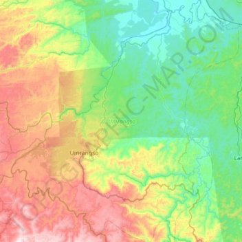
Name: Umrangso topographic map, elevation, terrain.

Location: Umrangso, Dima Hasao district, Assam, 788931, India (25.31862 92.56438 25.82894 93.09561)

Average elevation: 434 m

Minimum elevation: 69 m

Maximum elevation: 1,262 m

Other topographic maps

Click on a map to view its topography, its elevation and its terrain.

4 Kilo

India > Assam > Umrangso

Average elevation: 623 m

Gear up for your next adventure:

💡Solar Camping Lamp - Eco-friendly lighting for campsites
🥾Lightweight Hiking Shoes - Comfortable shoes for day hikes
🥘Camping Cookware Set - Compact nesting pots and pans for trail cooking
🧴Outdoor Sunscreen - High SPF protection for high-altitude UV exposure
🧥Softshell Hiking Jacket - The perfect balance of wind protection and breathability

As an Amazon Associate, this site earns from qualifying purchases at no extra cost to you.