Geolocate

4 Kilo topographic map

Click on the map to display elevation.

About this map

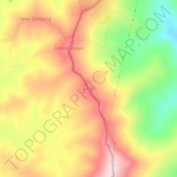
Name: 4 Kilo topographic map, elevation, terrain.

Location: 4 Kilo, Umrangso, Dima Hasao District, Assam, 788931, India (25.46070 92.70768 25.50070 92.74768)

Average elevation: 623 m

Minimum elevation: 418 m

Maximum elevation: 792 m

Other topographic maps

Click on a map to view its topography, its elevation and its terrain.

Umrangso

India > Assam > Umrangso

Average elevation: 434 m

Gear up for your next adventure:

🧦Hiking Socks - Moisture-wicking and comfortable socks for long hikes
🐕Hiking Dog Pack - Let your canine companion carry their own water and food
🧦Merino Wool Socks - Moisture-wicking comfort for long-distance hiking
🥾Waterproof Hiking Boots - Boots keeping your feet dry in wet conditions
🕶️Polarized Sunglasses - Reduces glare from snow and water at high elevations

As an Amazon Associate, this site earns from qualifying purchases at no extra cost to you.