Geolocate

Mesocco topographic map

Click on the map to display elevation.

About this map

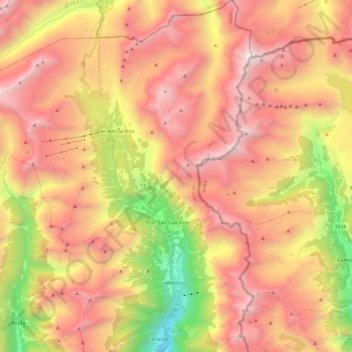
Name: Mesocco topographic map, elevation, terrain.

Location: Mesocco, Moësa, Grisons, Switzerland (46.35984 9.07860 46.52322 9.28437)

Average elevation: 2,060 m

Minimum elevation: 541 m

Maximum elevation: 3,230 m

Other topographic maps

Click on a map to view its topography, its elevation and its terrain.

Montoi

Switzerland > Grisons > Moësa > San Vittore

Average elevation: 798 m

Pian San Giacomo

Switzerland > Grisons > Moësa

Average elevation: 1,568 m

Valle Mesolcina

Switzerland > Grisons > Moësa

Average elevation: 1,675 m

Tingés

Switzerland > Grisons > Moësa > Soazza

Average elevation: 1,044 m

Scot

Switzerland > Grisons > Moësa > Mesocco > Spina

Average elevation: 1,572 m

Logiano

Switzerland > Grisons > Moësa > Mesocco > Logiano

Average elevation: 1,336 m

Gear up for your next adventure:

👖Convertible Hiking Pants - Zip-off legs to adapt to changing weather conditions
🥾Trail Hiking Socks - Comfortable socks to prevent blisters and fatigue
🎒Backpack Rain Cover - External shield to keep your entire pack dry
🦶Anti-Blister Balm - Prevents friction and hotspots during long ascents
💡LED Camping Lantern - Illuminate your campsite with long-lasting lanterns

As an Amazon Associate, this site earns from qualifying purchases at no extra cost to you.