Geolocate

Felbridge topographic map

Click on the map to display elevation.

About this map

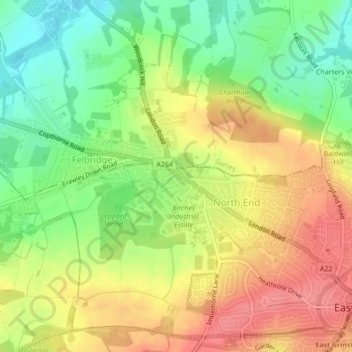
Name: Felbridge topographic map, elevation, terrain.

Location: Felbridge, North End, East Grinstead, Mid Sussex, West Sussex, England, RH19 2QP, United Kingdom (51.12859 -0.04797 51.14859 -0.02797)

Average elevation: 98 m

Minimum elevation: 59 m

Maximum elevation: 134 m

Other topographic maps

Click on a map to view its topography, its elevation and its terrain.

Gear up for your next adventure:

🥾Mountain Trail Shoes - High-traction shoes for mountain trails
📷Outdoor Action Camera - Capture high-elevation views and rugged adventures
🦶Hiking Shoe Insoles - Added support for high arches and long days on feet
🛶Kayak Accessories - Essential gear for safe and fun kayaking adventures
🔋Lithium AA Batteries - Long-lasting power that performs in extreme cold

As an Amazon Associate, this site earns from qualifying purchases at no extra cost to you.