Geolocate

Cadiz topographic map

Click on the map to display elevation.

About this map

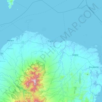
Name: Cadiz topographic map, elevation, terrain.

Location: Cadiz, Negros Occidental, Western Visayas, 6121, Philippines (10.68673 123.12429 11.13784 123.37481)

Average elevation: 116 m

Minimum elevation: -2 m

Maximum elevation: 1,504 m

Other topographic maps

Click on a map to view its topography, its elevation and its terrain.

Inayawan

Philippines > Negros Occidental

Average elevation: 20 m

Andies

Philippines > Negros Occidental

Average elevation: 37 m

Gear up for your next adventure:

🛏️Sleeping Bag - Warm and compact sleeping bags for outdoor camping
Camping Tent - Weather-resistant tents suitable for 2 to 6 people
🛰️Satellite Messenger - Emergency communication for areas with no cell service
🧊Insulated Water Bottle - Keeps drinks cold in summer and prevents freezing in winter
🧦Thermal Socks - Warm socks for winter hiking or camping

As an Amazon Associate, this site earns from qualifying purchases at no extra cost to you.