Geolocate

Andies topographic map

Click on the map to display elevation.

About this map

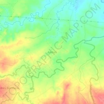
Name: Andies topographic map, elevation, terrain.

Location: Andies, Negros Occidental, Western Visayas, Philippines (10.89794 123.22856 10.93794 123.26856)

Average elevation: 37 m

Minimum elevation: 5 m

Maximum elevation: 72 m

Other topographic maps

Click on a map to view its topography, its elevation and its terrain.

Cadiz

Philippines > Negros Occidental

Average elevation: 116 m

Hinoba-an

Philippines > Negros Occidental

Average elevation: 56 m

Murcia

Philippines > Negros Occidental

Average elevation: 277 m

Gear up for your next adventure:

🕶️Polarized Sunglasses - Reduces glare from snow and water at high elevations
🧊Portable Cooler - Keep food and drinks cold during outdoor adventures
🦯Trekking Poles - Reduced impact on joints for steep topographic climbs
🔥Camping Stove - Portable stoves to cook outdoors with ease
🛶Kayak Accessories - Essential gear for safe and fun kayaking adventures

As an Amazon Associate, this site earns from qualifying purchases at no extra cost to you.