
Salvaleón topographic map
Interactive map
Click on the map to display elevation.
About this map
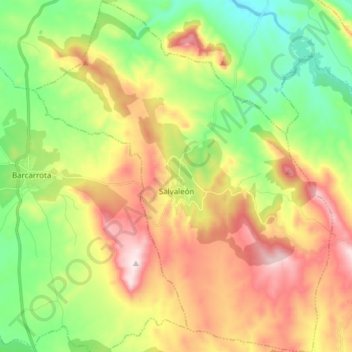
Name: Salvaleón topographic map, elevation, terrain.
Location: Salvaleón, Sierra Suroeste, Badajoz, Extremadura, España (38.45566 -6.84843 38.57528 -6.71837)
Average elevation: 531 m
Minimum elevation: 325 m
Maximum elevation: 806 m
Other topographic maps
Click on a map to view its topography, its elevation and its terrain.
Jerez de los Caballeros
España > Extremadura > Sierra Suroeste
Jerez de los Caballeros, Sierra Suroeste, Badajoz, Extremadura, 06380, España
Average elevation: 446 m
Oliva de la Frontera
España > Extremadura > Sierra Suroeste
Oliva de la Frontera, Sierra Suroeste, Badajoz, Extremadura, España
Average elevation: 334 m