Geolocate

Sherman topographic map

Click on the map to display elevation.

About this map

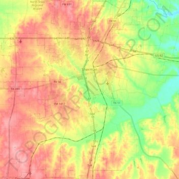
Name: Sherman topographic map, elevation, terrain.

Location: Sherman, Grayson County, Texas, United States (33.53014 -96.71577 33.70917 -96.54843)

Average elevation: 228 m

Minimum elevation: 171 m

Maximum elevation: 276 m

Other topographic maps

Click on a map to view its topography, its elevation and its terrain.

Pottsboro

United States > Texas > Grayson County

Average elevation: 226 m

Gear up for your next adventure:

🧢Beanie Hat - Keep your head warm in cold weather
🧢Sun Hat - Wide-brim hat for sun protection
💡Compact LED Flashlight - Powerful and portable flashlight for outdoor use
Lightweight Backpacking Tent - Compact tent for efficient hiking trips
🛁Quick-Dry Microfiber Towel - Space-saving towel that dries rapidly on the move

As an Amazon Associate, this site earns from qualifying purchases at no extra cost to you.