Geolocate

Pottsboro topographic map

Click on the map to display elevation.

About this map

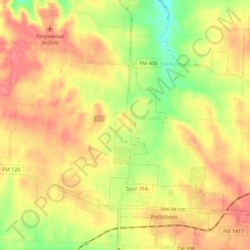
Name: Pottsboro topographic map, elevation, terrain.

Location: Pottsboro, Grayson County, Texas, United States (33.75192 -96.70138 33.81913 -96.64759)

Average elevation: 226 m

Minimum elevation: 187 m

Maximum elevation: 252 m

Other topographic maps

Click on a map to view its topography, its elevation and its terrain.

Pottsboro

United States > Texas > Grayson County > Pottsboro

Average elevation: 227 m

Sherman

United States > Texas > Grayson County

Average elevation: 228 m

Gear up for your next adventure:

🔋Lithium AA Batteries - Long-lasting power that performs in extreme cold
💡Solar Camping Lamp - Eco-friendly lighting for campsites
🚲Handlebar Phone Mount - View topographic-map.com live while cycling
🥾Lightweight Hiking Boots - Boots for comfort and mobility on long hikes
🧢Sun Hat - Wide-brim hat for sun protection

As an Amazon Associate, this site earns from qualifying purchases at no extra cost to you.