Geolocate

Casares topographic map

Click on the map to display elevation.

About this map

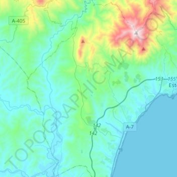
Name: Casares topographic map, elevation, terrain.

Location: Casares, Costa del Sol Occidental, Malaga, Andalusia, Spain (36.32507 -5.35805 36.52062 -5.20528)

Average elevation: 224 m

Minimum elevation: 0 m

Maximum elevation: 1,436 m

Other topographic maps

Click on a map to view its topography, its elevation and its terrain.

Madrid

Spain > Andalusia > Costa del Sol Occidental > Casares

Average elevation: 737 m

Chaparral

Spain > Andalusia > Costa del Sol Occidental

Average elevation: 29 m

Mijas Golf

Spain > Andalusia > Costa del Sol Occidental

Average elevation: 58 m

Artola

Spain > Andalusia > Costa del Sol Occidental > Marbella

Average elevation: 55 m

Entrerríos

Spain > Andalusia > Costa del Sol Occidental

Average elevation: 121 m

Bel-Air

Spain > Andalusia > Costa del Sol Occidental > Estepona

Average elevation: 35 m

Rícmar

Spain > Andalusia > Costa del Sol Occidental > Marbella

Average elevation: 35 m

La Concha

Spain > Andalusia > Costa del Sol Occidental > Marbella

Average elevation: 784 m

Gear up for your next adventure:

🔦LED Headlamp - Hands-free lighting for early morning starts or late finishes
🧶550 Survival Paracord - Versatile utility cord for emergency repairs and rigging
🛰️Satellite Messenger - Emergency communication for areas with no cell service
🧴Outdoor Sunscreen - High SPF protection for high-altitude UV exposure
🧥Softshell Hiking Jacket - The perfect balance of wind protection and breathability

As an Amazon Associate, this site earns from qualifying purchases at no extra cost to you.