Geolocate

Irma topographic map

Click on the map to display elevation.

About this map

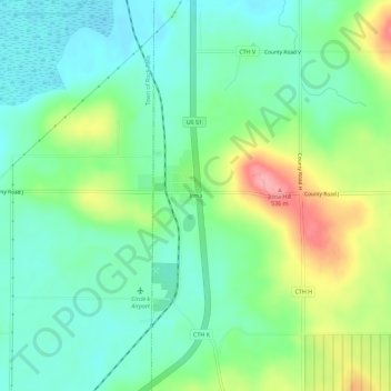
Name: Irma topographic map, elevation, terrain.

Location: Irma, Town of Birch, Lincoln County, Wisconsin, 54442, United States (45.33135 -89.68652 45.37135 -89.64652)

Average elevation: 465 m

Minimum elevation: 431 m

Maximum elevation: 536 m

Other topographic maps

Click on a map to view its topography, its elevation and its terrain.

Merrill

United States > Wisconsin > Lincoln County

Average elevation: 398 m

Tomahawk

United States > Wisconsin > Lincoln County

Average elevation: 443 m

Merrill

United States > Wisconsin > Lincoln County

Average elevation: 398 m

Tomahawk

United States > Wisconsin > Lincoln County

Average elevation: 443 m

Merrill

United States > Wisconsin > Lincoln County

Average elevation: 398 m

Tomahawk

United States > Wisconsin > Lincoln County

Average elevation: 443 m

Gear up for your next adventure:

🥾Trekking Poles - Adjustable trekking poles to reduce knee stress and improve stability
🧭GPS Tracker - Track your location in remote areas safely
🗺️Topographic Maps - Detailed maps to explore trails, mountains, and wilderness areas
🦯Trekking Poles - Reduced impact on joints for steep topographic climbs
🛶Waterproof Dry Bags - Keep electronics and clothes dry during river crossings

As an Amazon Associate, this site earns from qualifying purchases at no extra cost to you.