Geolocate

Merrill topographic map

Click on the map to display elevation.

About this map

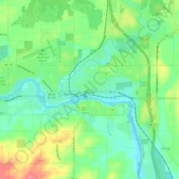
Name: Merrill topographic map, elevation, terrain.

Location: Merrill, Lincoln County, Wisconsin, United States (45.15669 -89.75895 45.20666 -89.64733)

Average elevation: 398 m

Minimum elevation: 374 m

Maximum elevation: 449 m

Other topographic maps

Click on a map to view its topography, its elevation and its terrain.

Irma

United States > Wisconsin > Lincoln County

Average elevation: 465 m

Dudley

United States > Wisconsin > Lincoln County

Average elevation: 462 m

Gear up for your next adventure:

🧥Softshell Hiking Jacket - The perfect balance of wind protection and breathability
🛶Waterproof Dry Bags - Keep electronics and clothes dry during river crossings
🚲Heavy Duty Bike Lock - Secure your bike at the trailhead or during stops
🧊Portable Cooler - Keep food and drinks cold during outdoor adventures
Lightweight Backpacking Tent - Compact tent for efficient hiking trips

As an Amazon Associate, this site earns from qualifying purchases at no extra cost to you.