Geolocate

Githunguri ward topographic map

Click on the map to display elevation.

About this map

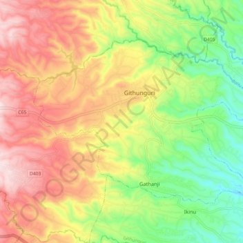
Name: Githunguri ward topographic map, elevation, terrain.

Location: Githunguri ward, Githunguri, Kiambu, Central Kenya, Kenya (-1.09746 36.73936 -1.03689 36.82896)

Average elevation: 1,924 m

Minimum elevation: 1,732 m

Maximum elevation: 2,124 m

Other topographic maps

Click on a map to view its topography, its elevation and its terrain.

Kambaa

Kenya > Kiambu > Githunguri > Githiga ward

Average elevation: 2,115 m

Gatamaiyu River

Kenya > Kiambu > Githunguri > Komothai

Average elevation: 1,823 m

Kibichoi

Kenya > Kiambu > Githunguri

Average elevation: 1,718 m

Githunguri

Kenya > Kiambu > Githunguri > Githunguri ward

Average elevation: 1,930 m

Ikinu

Kenya > Kiambu > Githunguri > Ikinu ward

Average elevation: 1,814 m

Gear up for your next adventure:

🥾Lightweight Hiking Shoes - Comfortable shoes for day hikes
🧴Outdoor Sunscreen - High SPF protection for high-altitude UV exposure
👟Leg Gaiters - Keep debris, mud, and snow out of your boots
🥾Mountain Trail Shoes - High-traction shoes for mountain trails
🔦UV Flashlight - Detect minerals or specific insects in the dark

As an Amazon Associate, this site earns from qualifying purchases at no extra cost to you.