Geolocate

Santa Claus topographic map

Click on the map to display elevation.

About this map
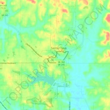
Name: Santa Claus topographic map, elevation, terrain.

Location: Santa Claus, Spencer County, Indiana, 47579, United States (38.08941 -86.97974 38.15691 -86.89805)

Average elevation: 143 m

Minimum elevation: 121 m

Maximum elevation: 180 m

Other topographic maps

Click on a map to view its topography, its elevation and its terrain.
Lincoln City

United States > Indiana > Spencer County

Average elevation: 137 m

Huffman

United States > Indiana > Spencer County

Average elevation: 141 m

Gear up for your next adventure:

🧥Ultralight Puffy Jacket - Maximum warmth that packs down to the size of an orange
🔦LED Headlamp - Hands-free lighting for early morning starts or late finishes
🧣Evaporative Cooling Towel - Beat the heat during intense summer climbs
⛺Backpacking Tent - Lightweight tent for long-distance hiking trips
🔭Compact Monocular - One-handed bird watching and trail spotting

As an Amazon Associate, this site earns from qualifying purchases at no extra cost to you.