Geolocate

New Boston topographic map

Click on the map to display elevation.

About this map
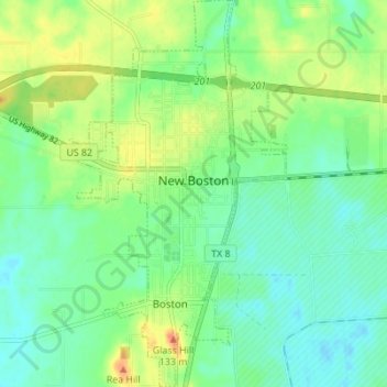
Name: New Boston topographic map, elevation, terrain.

Location: New Boston, Bowie County, Texas, 75570, United States (33.42926 -94.43907 33.48670 -94.39897)

Average elevation: 108 m

Minimum elevation: 94 m

Maximum elevation: 133 m

Other topographic maps

Click on a map to view its topography, its elevation and its terrain.

Old Salem

United States > Texas > Bowie County

Average elevation: 110 m

Dalby Springs

United States > Texas > Bowie County

Average elevation: 96 m

Eylau

United States > Texas > Bowie County

Average elevation: 93 m

Eylau

United States > Texas > Bowie County

Average elevation: 93 m

Gear up for your next adventure:

🧥Packable Rain Jacket - Breathable waterproof layer for unpredictable weather
🥾Mountain Trail Shoes - High-traction shoes for mountain trails
🧢Outdoor Cap - Protective cap for sun and rain during hikes
🧥Thermal Layer - Insulating layer for cold outdoor conditions
🥽Outdoor Goggles - Protective eyewear for outdoor activities

As an Amazon Associate, this site earns from qualifying purchases at no extra cost to you.