
Aadloun topographic map
Interactive map
Click on the map to display elevation.
About this map
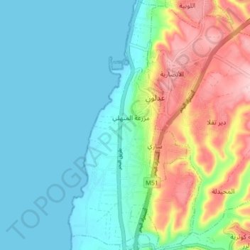
Name: Aadloun topographic map, elevation, terrain.
Location: Aadloun, District de Sidon, Gouvernorat du Liban Sud, Liban (33.36921 35.25009 33.42754 35.27667)
Average elevation: 51 m
Minimum elevation: -4 m
Maximum elevation: 175 m
Other topographic maps
Click on a map to view its topography, its elevation and its terrain.
Tyr
Liban > Gouvernorat du Liban Sud > Tyr
Tyr, District de Tyr, Gouvernorat du Liban Sud, 1601, Liban
Average elevation: 120 m