Geolocate

Cambaul topographic map

Click on the map to display elevation.

About this map

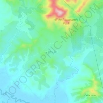
Name: Cambaul topographic map, elevation, terrain.

Location: Cambaul, Bohol, Central Visayas, 6314, Philippines (9.89702 124.44804 9.93702 124.48804)

Average elevation: 74 m

Minimum elevation: 5 m

Maximum elevation: 323 m

Other topographic maps

Click on a map to view its topography, its elevation and its terrain.

Bingag

Philippines > Bohol > Dauis

Average elevation: 19 m

Boyo-an

Philippines > Bohol > Candijay

Average elevation: 43 m

Panglao

Philippines > Bohol > Panglao

Average elevation: 4 m

Gear up for your next adventure:

🧥Thermal Layer - Insulating layer for cold outdoor conditions
🛶Waterproof Dry Bags - Keep electronics and clothes dry during river crossings
🥾Waterproof Trail Shoes - Shoes designed to handle wet terrain
🥾Durable Hiking Shoes - Long-lasting shoes for frequent hiking
🔥Camping Stove - Portable stoves to cook outdoors with ease

As an Amazon Associate, this site earns from qualifying purchases at no extra cost to you.