Geolocate

Lake Whitney topographic map

Click on the map to display elevation.

About this map

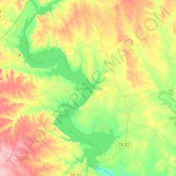
Name: Lake Whitney topographic map, elevation, terrain.

Location: Lake Whitney, Bosque County, Texas, United States (31.85519 -97.51359 32.10473 -97.32887)

Average elevation: 193 m

Minimum elevation: 132 m

Maximum elevation: 279 m

Other topographic maps

Click on a map to view its topography, its elevation and its terrain.

Cayote

United States > Texas > Bosque County

Average elevation: 225 m

Kopperl

United States > Texas > Bosque County

Average elevation: 176 m

Laguna Park

United States > Texas > Bosque County

Average elevation: 175 m

Mosheim

United States > Texas > Bosque County

Average elevation: 286 m

Gear up for your next adventure:

💧Hydration Pack - Hands-free hydration system for long hikes
🔦LED Flashlight - Powerful and long-lasting flashlight for camping and emergencies
🧥Thermal Fleece Jacket - Versatile insulation for changing mountain temperatures
🥾Mountain Hiking Boots - High-traction boots for rocky terrain
🧴Insect Repellent - Protect yourself from bugs during outdoor adventures

As an Amazon Associate, this site earns from qualifying purchases at no extra cost to you.