Mathioya topographic map
Interactive map
Click on the map to display elevation.
About this map
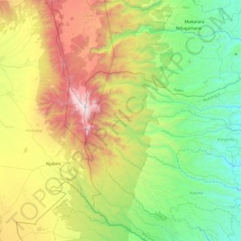
Name: Mathioya topographic map, elevation, terrain.
Location: Mathioya, Murang'a County, Central Kenya, Kenya (-0.73731 36.70649 -0.56733 37.12397)
Average elevation: 2,388 m
Minimum elevation: 1,609 m
Maximum elevation: 3,859 m
Other topographic maps
Click on a map to view its topography, its elevation and its terrain.
Gatanga
Gatanga, Murang'a County, Central Kenya, Kenya
Average elevation: 1,838 m
Kigumo
Kigumo, Murang'a County, Central Kenya, Kenya
Average elevation: 1,959 m
Kangema
Kangema, Murang'a County, Central Kenya, 10202, Kenya
Average elevation: 1,828 m
Maragua
Kenya > Murang'a County > Murang`a South
Maragua, Murang`a South, Murang'a County, Central Kenya, Kenya
Average elevation: 1,355 m
Kiharu
Kiharu, Murang'a County, Central Kenya, 10200, Kenya
Average elevation: 1,370 m
Kandara
Kandara, Murang'a County, Central Kenya, Kenya
Average elevation: 1,593 m