Geolocate

Knightstown topographic map

Click on the map to display elevation.

About this map

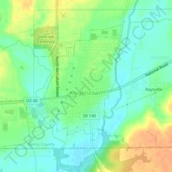
Name: Knightstown topographic map, elevation, terrain.

Location: Knightstown, Henry County, Indiana, United States (39.78703 -85.54650 39.80627 -85.51879)

Average elevation: 285 m

Minimum elevation: 270 m

Maximum elevation: 308 m

Other topographic maps

Click on a map to view its topography, its elevation and its terrain.

Greensboro

United States > Indiana > Henry County

Average elevation: 304 m

Millville

United States > Indiana > Henry County

Average elevation: 347 m

New Lisbon

United States > Indiana > Henry County

Average elevation: 332 m

Hillsboro

United States > Indiana > Henry County

Average elevation: 326 m

Gear up for your next adventure:

🥾Lightweight Hiking Shoes - Comfortable shoes for day hikes
🚲Bike Repair Kit - Essential tools for on-trail mechanical issues
Camping Groundsheet - Protect your tent from moisture and dirt
🪑Insulated Seat Pad - Protect your seat from cold rocks and wet logs
🎒Backpack Rain Cover - External shield to keep your entire pack dry

As an Amazon Associate, this site earns from qualifying purchases at no extra cost to you.