Geolocate

Wooler topographic map

Click on the map to display elevation.

About this map

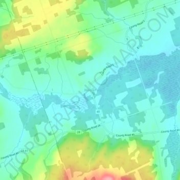
Name: Wooler topographic map, elevation, terrain.

Location: Wooler, Quinte West, Central Ontario, Ontario, Canada (44.13715 -77.72066 44.17715 -77.68066)

Average elevation: 145 m

Minimum elevation: 117 m

Maximum elevation: 222 m

Ontario trails, hiking, mountain biking, running and outdoor activities

Other topographic maps

Click on a map to view its topography, its elevation and its terrain.

Frankford

Canada > Ontario > Quinte West

Average elevation: 126 m

Trenton

Canada > Ontario > Quinte West

Average elevation: 90 m

Murray

Canada > Ontario > Quinte West

Average elevation: 124 m

Trenton

Canada > Ontario > Quinte West

Average elevation: 90 m

Gear up for your next adventure:

🥾Trekking Poles - Adjustable trekking poles to reduce knee stress and improve stability
🔭Compact Monocular - One-handed bird watching and trail spotting
Camping Coffee Maker - Brew fresh coffee anywhere on the topographic map
🧼Biodegradable Camp Soap - Environmentally friendly cleaning for gear and body
🧴First Aid Kit - Essential first aid supplies for outdoor emergencies

As an Amazon Associate, this site earns from qualifying purchases at no extra cost to you.