Geolocate

Vallberget topographic map

Click on the map to display elevation.

About this map

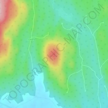
Name: Vallberget topographic map, elevation, terrain.

Location: Vallberget, Hagfors kommun, Värmland County, Sweden (60.18922 13.41578 60.18932 13.41588)

Average elevation: 205 m

Minimum elevation: 141 m

Maximum elevation: 359 m

Other topographic maps

Click on a map to view its topography, its elevation and its terrain.

Hammarö kommun

Sweden > Värmland County

Average elevation: 45 m

Kils kommun

Sweden > Värmland County

Average elevation: 104 m

Torsby kommun

Sweden > Värmland County

Average elevation: 356 m

Sunne kommun

Sweden > Värmland County

Average elevation: 194 m

Hammarö kommun

Sweden > Värmland County

Average elevation: 45 m

Hagfors kommun

Sweden > Värmland County

Average elevation: 257 m

Säffle kommun

Sweden > Värmland County

Average elevation: 89 m

Filipstads kommun

Sweden > Värmland County

Average elevation: 241 m

Pottern

Sweden > Värmland County

Average elevation: 145 m

Karlstads kommun

Sweden > Värmland County

Average elevation: 109 m

Storfors kommun

Sweden > Värmland County

Average elevation: 158 m

Gear up for your next adventure:

🧥Fleece Jacket - Warm and lightweight jacket for layering
Backpacking Tent - Lightweight tent for long-distance hiking trips
🔦LED Headtorch - Bright and durable light for night activities
🥾Hiking Leggings - Comfortable leggings for outdoor activities
🥾Lightweight Hiking Boots - Boots for comfort and mobility on long hikes

As an Amazon Associate, this site earns from qualifying purchases at no extra cost to you.