
Make a donation
Gear up for your next adventure:
As an Amazon Associate, this site earns from qualifying purchases at no extra cost to you.
Delaplane Manor topographic map
Click on the map to display elevation.
Make a donation
Gear up for your next adventure:
As an Amazon Associate, this site earns from qualifying purchases at no extra cost to you.
About this map
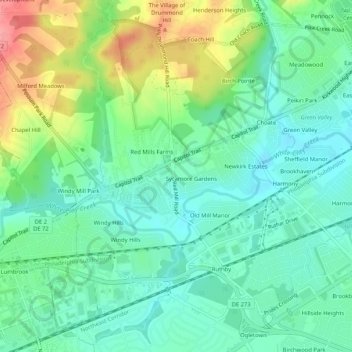
Name: Delaplane Manor topographic map, elevation, terrain.
Average elevation: 34 m
Minimum elevation: 5 m
Maximum elevation: 98 m
Make a donation
Gear up for your next adventure:
As an Amazon Associate, this site earns from qualifying purchases at no extra cost to you.
Other topographic maps
Click on a map to view its topography, its elevation and its terrain.
Wilmington
United States > Delaware > New Castle County
On the western side of Market Street, the Piedmont topography is rocky and hilly, rising to a point that marks the watershed between the Brandywine River and the Christina River. This watershed line runs along Delaware Avenue westward from 10th Street and Market Street.
Average elevation: 20 m
Make a donation
Gear up for your next adventure:
As an Amazon Associate, this site earns from qualifying purchases at no extra cost to you.
Middletown
United States > Delaware > New Castle County
Middletown is located at 39°26′58″N 75°42′59″W / 39.44944°N 75.71639°W / 39.44944; -75.71639 (39.4495560, –75.7163207) with an elevation of 66 feet (20.1 m).
Average elevation: 17 m
Brandywine Creek State Park
United States > Delaware > New Castle County > Talleyville
Average elevation: 93 m
Make a donation
Gear up for your next adventure:
As an Amazon Associate, this site earns from qualifying purchases at no extra cost to you.
Carousel Park and Equestrian Center
United States > Delaware > New Castle County > Carousel Knoll
Average elevation: 56 m
Cool Spring Reservoir
United States > Delaware > New Castle County > Wilmington
Average elevation: 38 m
Make a donation
Gear up for your next adventure:
As an Amazon Associate, this site earns from qualifying purchases at no extra cost to you.
Middletown
United States > Delaware > New Castle County
Middletown is located at 39°26′58″N 75°42′59″W / 39.44944°N 75.71639°W / 39.44944; -75.71639 (39.4495560, –75.7163207) with an elevation of 66 feet (20.1 m).
Average elevation: 17 m
Make a donation
Gear up for your next adventure:
As an Amazon Associate, this site earns from qualifying purchases at no extra cost to you.
Wilmington
United States > Delaware > New Castle County
On the western side of Market Street, the Piedmont topography is rocky and hilly, rising to a point that marks the watershed between the Brandywine River and the Christina River. This watershed line runs along Delaware Avenue westward from 10th Street and Market Street.
Average elevation: 20 m
Make a donation
Gear up for your next adventure:
As an Amazon Associate, this site earns from qualifying purchases at no extra cost to you.
Make a donation
Gear up for your next adventure:
As an Amazon Associate, this site earns from qualifying purchases at no extra cost to you.
Hockessin, Delaware
United States > Delaware > New Castle County > Hockessin, Delaware
Average elevation: 96 m