
Make a donation
Gear up for your next adventure:
As an Amazon Associate, this site earns from qualifying purchases at no extra cost to you.
Hockessin topographic map
Click on the map to display elevation.
Make a donation
Gear up for your next adventure:
As an Amazon Associate, this site earns from qualifying purchases at no extra cost to you.
About this map
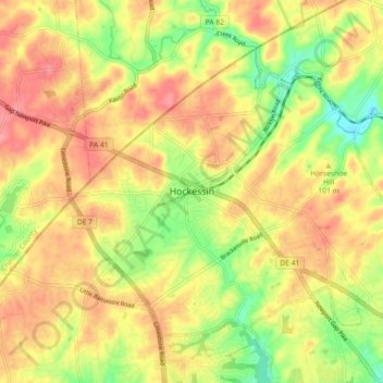
Name: Hockessin topographic map, elevation, terrain.
Location: Hockessin, New Castle County, Delaware, United States (39.76150 -75.72500 39.81360 -75.63489)
Average elevation: 93 m
Minimum elevation: 33 m
Maximum elevation: 135 m
Make a donation
Gear up for your next adventure:
As an Amazon Associate, this site earns from qualifying purchases at no extra cost to you.
Other topographic maps
Click on a map to view its topography, its elevation and its terrain.
Yorklyn
United States > Delaware > New Castle County > Hockessin
Yorklyn is an unincorporated community in northern New Castle County, Delaware, United States. It lies along Delaware Route 82 northwest of the city of Wilmington, the county seat of New Castle County. Its elevation is 174 feet (53 m). It has a post office with the ZIP code 19736.
Average elevation: 91 m
Meeting House Meadows
United States > Delaware > New Castle County > Hockessin
Average elevation: 95 m