
Böblingen topographic map
Click on the map to display elevation.
About this map
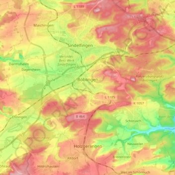
Name: Böblingen topographic map, elevation, terrain.
Location: Böblingen, Landkreis Böblingen, Baden-Württemberg, Germany (48.65502 8.93224 48.70376 9.11405)
Average elevation: 466 m
Minimum elevation: 365 m
Maximum elevation: 549 m
Other topographic maps
Click on a map to view its topography, its elevation and its terrain.
Merklingen
Germany > Baden-Württemberg > Landkreis Böblingen > Weil der Stadt
Average elevation: 436 m