Geolocate

Shirebrook topographic map

Click on the map to display elevation.

About this map

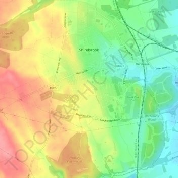
Name: Shirebrook topographic map, elevation, terrain.

Location: Shirebrook, Bolsover, Derbyshire, East Midlands, England, United Kingdom (53.18061 -1.24080 53.21626 -1.19506)

Average elevation: 114 m

Minimum elevation: 71 m

Maximum elevation: 159 m

Other topographic maps

Click on a map to view its topography, its elevation and its terrain.

Riddings

United Kingdom > England > Derbyshire > Amber Valley

Average elevation: 117 m

Glossop

United Kingdom > England > Derbyshire > High Peak

Average elevation: 284 m

Birch Vale

United Kingdom > England > Derbyshire > High Peak > New Mills > Hayfield

Average elevation: 251 m

Dove Holes

United Kingdom > England > Derbyshire > High Peak

Average elevation: 357 m

Dalbury

United Kingdom > England > Derbyshire > South Derbyshire

Average elevation: 76 m

Langley Mill

United Kingdom > England > Derbyshire > Amber Valley

Average elevation: 100 m

Ilkeston

United Kingdom > England > Derbyshire > Erewash

Average elevation: 81 m

Lose Hill

United Kingdom > England > Derbyshire > High Peak

Average elevation: 265 m

Sawmills

United Kingdom > England > Derbyshire > Amber Valley > Ripley > Fritchley

Average elevation: 119 m

Mam Tor

United Kingdom > England > Derbyshire > High Peak

Average elevation: 347 m

Gear up for your next adventure:

🥾Mountain Hiking Boots - High-traction boots for rocky terrain
🥾Hiking Boots - Sturdy boots providing ankle support and traction on rugged trails
🔋Solar Power Bank - Keep your GPS and devices charged during long outdoor trips
🥾Trail Running Shoes - Lightweight and durable shoes for trail running
💧Hydration Pack - Hands-free hydration system for long hikes

As an Amazon Associate, this site earns from qualifying purchases at no extra cost to you.