
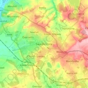
Swadlincote topographic map
Interactive map
Click on the map to display elevation.
About this map
Name: Swadlincote topographic map, elevation, terrain.
Average elevation: 109 m
Minimum elevation: 42 m
Maximum elevation: 183 m
Other topographic maps
Click on a map to view its topography, its elevation and its terrain.
Dalbury
United Kingdom > England > Derbyshire > South Derbyshire
Dalbury, Dalbury Lees CP, South Derbyshire, Derbyshire, England, DE6 5BR, United Kingdom
Average elevation: 76 m
Findern CP
United Kingdom > England > Derbyshire > South Derbyshire
Findern CP, South Derbyshire, Derbyshire, England, United Kingdom
Average elevation: 58 m
Willington CP
United Kingdom > England > Derbyshire > South Derbyshire > Willington CP
Willington CP, South Derbyshire, Derbyshire, East Midlands, England, United Kingdom
Average elevation: 51 m