Geolocate

Crawford topographic map

Click on the map to display elevation.

About this map

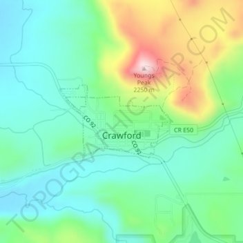
Name: Crawford topographic map, elevation, terrain.

Location: Crawford, Delta County, Colorado, United States (38.70138 -107.61832 38.70951 -107.60221)

Average elevation: 2,020 m

Minimum elevation: 1,922 m

Maximum elevation: 2,251 m

Other topographic maps

Click on a map to view its topography, its elevation and its terrain.

Eckert

United States > Colorado > Delta County

Average elevation: 1,691 m

Mount Lamborn

United States > Colorado > Delta County

Average elevation: 2,949 m

Crater Peak

United States > Colorado > Delta County

Average elevation: 3,236 m

Cedaredge

United States > Colorado > Delta County

Located in a protected valley at 6,100 feet (1,900 m) in elevation, the Cedaredge Golf Club course has natural cedars and winding creek beds.

Average elevation: 1,883 m

Eckert

United States > Colorado > Delta County

Average elevation: 1,691 m

Gear up for your next adventure:

Camping Tent - Weather-resistant tents suitable for 2 to 6 people
🔦LED Flashlight - Powerful and long-lasting flashlight for camping and emergencies
📷Outdoor Action Camera - Capture high-elevation views and rugged adventures
💡Solar Camping Lamp - Eco-friendly lighting for campsites
🧥Softshell Hiking Jacket - The perfect balance of wind protection and breathability

As an Amazon Associate, this site earns from qualifying purchases at no extra cost to you.