Geolocate

Morales topographic map

Click on the map to display elevation.

About this map

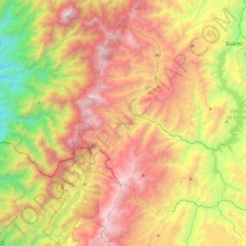
Name: Morales topographic map, elevation, terrain.

Location: Morales, Centro, Cauca, 190559, Colombia (2.70828 -76.91675 2.97957 -76.57573)

Average elevation: 1,705 m

Minimum elevation: 193 m

Maximum elevation: 3,338 m

Other topographic maps

Click on a map to view its topography, its elevation and its terrain.

Toscana Circle

Colombia > Cauca > Popayán

Average elevation: 1,735 m

Torres

Colombia > Cauca > La Sierra

Average elevation: 1,759 m

MONDOMO

Colombia > Cauca > Santander de Quilichao

Average elevation: 1,397 m

Rio Negro

Colombia > Cauca > Puracé

Average elevation: 3,199 m

Peña Del Condado

Colombia > Cauca > Silvia > Peña Del Condado

Average elevation: 2,922 m

Páramo de Santo Domingo

Colombia > Cauca > Toribío

Average elevation: 3,886 m

El Condor

Colombia > Cauca > El Condor

Average elevation: 1,950 m

Inzá

Colombia > Cauca > Inzá > Inzá

Average elevation: 1,876 m

Gear up for your next adventure:

💧Collapsible Water Bottle - Space-saving water bottle for outdoor activities
🧥Thermal Layer - Insulating layer for cold outdoor conditions
🏕️Camping Hammock - Integrated protection for sleeping between trees
🧥Ultralight Puffy Jacket - Maximum warmth that packs down to the size of an orange
🦌Outdoor Trail Camera - Monitor wildlife activity near your favorite spots

As an Amazon Associate, this site earns from qualifying purchases at no extra cost to you.