Geolocate

Brill topographic map

Click on the map to display elevation.

About this map
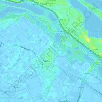
Name: Brill topographic map, elevation, terrain.

Location: Brill, Voorne aan Zee, South Holland, Netherlands (51.88350 4.13529 51.93141 4.22922)

Average elevation: 2 m

Minimum elevation: -4 m

Maximum elevation: 19 m

Other topographic maps

Click on a map to view its topography, its elevation and its terrain.

Tweede Tol

Netherlands > South Holland > Dordrecht

Average elevation: 0 m

Gooland

Netherlands > South Holland > Nootdorp

Average elevation: -2 m

Langeraar

Netherlands > South Holland

Average elevation: -3 m

Waalhaven

Netherlands > South Holland > Rotterdam

Average elevation: 3 m

Meijendel

Netherlands > South Holland > Wassenaar

Average elevation: 6 m

Meije

Netherlands > South Holland > Nieuwkoop

Average elevation: -2 m

Ankerpark

Netherlands > South Holland > Leiden

Average elevation: 3 m

Botlek

Netherlands > South Holland

Average elevation: 3 m

Weerestein

Netherlands > South Holland > Hillegom

Average elevation: 0 m

Weerestein

Netherlands > South Holland > Hillegom

Average elevation: 0 m

Coepelduynen

Netherlands > South Holland > Katwijk

Average elevation: 4 m

Middelsluis

Netherlands > South Holland > Numansdorp

Average elevation: 0 m

Broekhuizen

Netherlands > South Holland > Gouda

Average elevation: -1 m

Het Park

Netherlands > South Holland > Rotterdam

Average elevation: 4 m

Gear up for your next adventure:

💧Filtered Water Bottle - Safe drinking water on the go
🧰Survival Kit - Essential gear for emergencies in the wilderness
🧤Thermal Hiking Gloves - Grip-enhanced gloves for cold-weather altitude trekking
🛌Down Sleeping Bag - Superior warmth-to-weight ratio for cold nights
🔨Vehicle Emergency Tool - Safety tool for remote road trips to trailheads

As an Amazon Associate, this site earns from qualifying purchases at no extra cost to you.