Geolocate

Vazhoor topographic map

Click on the map to display elevation.

About this map

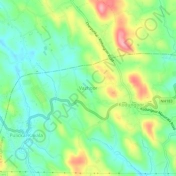
Name: Vazhoor topographic map, elevation, terrain.

Location: Vazhoor, Changanassery, Kottayam District, Kerala, 686504, India (9.55016 76.67592 9.59016 76.71592)

Average elevation: 91 m

Minimum elevation: 47 m

Maximum elevation: 168 m

Other topographic maps

Click on a map to view its topography, its elevation and its terrain.

Kurichy

India > Kerala > Changanassery > Putuppalli

Average elevation: 11 m

Mammoodu

India > Kerala > Changanassery > Mammood

Average elevation: 31 m

Cheeranchira

India > Kerala > Changanassery > Kurishummoodu

Average elevation: 18 m

Thrikkodithanam

India > Kerala > Changanassery > Valiyakulam

Average elevation: 22 m

Gear up for your next adventure:

🦌Outdoor Trail Camera - Monitor wildlife activity near your favorite spots
🧴Outdoor Sunscreen - High SPF protection for high-altitude UV exposure
🧳Compression Sacks - Maximize space in your backpack by shrinking gear
🧊Portable Cooler - Keep food and drinks cold during outdoor adventures
🥾Mountaineering Boots - Supportive boots for climbing and high-altitude hiking

As an Amazon Associate, this site earns from qualifying purchases at no extra cost to you.