
Town of Argyle topographic map
Interactive map
Click on the map to display elevation.
About this map
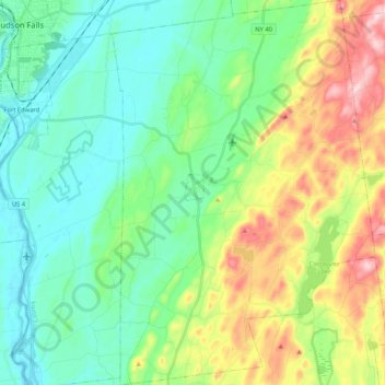
Name: Town of Argyle topographic map, elevation, terrain.
Location: Town of Argyle, Washington County, New York, United States (43.15815 -73.53544 43.31042 -73.39275)
Average elevation: 130 m
Minimum elevation: 30 m
Maximum elevation: 368 m
In the eastern part of the town, elevations increase, with several mountains reaching over 1,000 feet in height; with the highest being a few feet over 1,120 feet in height north of the hamlet of Goose Island. Two lakes, which both have extensive seasonal camps and year-round homes, are in this portion of the town; the spring-fed Summit Lake and further to the east, the larger Cossayuna Lake. From many locations in Argyle, the Adirondack Mountains can be viewed to the north and west and the Green Mountains of Vermont can be viewed to the east.
Other topographic maps
Click on a map to view its topography, its elevation and its terrain.
Black Mountain
United States > New York > Washington County
Black Mountain, Washington County, New York, 12841, United States
Average elevation: 487 m
Village of Whitehall
United States > New York > Washington County
Village of Whitehall, Town of Whitehall, Washington County, New York, United States
Average elevation: 84 m
Town of Hebron
United States > New York > Washington County
Town of Hebron, Washington County, New York, United States
Average elevation: 241 m