Geolocate

La Vega topographic map

Click on the map to display elevation.

About this map

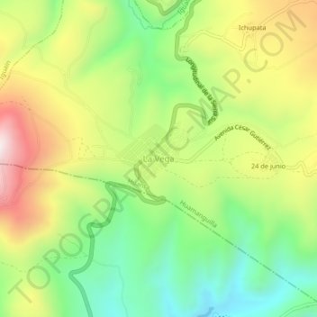
Name: La Vega topographic map, elevation, terrain.

Location: La Vega, Huamanguilla, Province of Huanta, Ayacucho, Peru (-13.04901 -74.23508 -13.00901 -74.19508)

Average elevation: 2,883 m

Minimum elevation: 2,564 m

Maximum elevation: 3,307 m

Other topographic maps

Click on a map to view its topography, its elevation and its terrain.

Puquio

Peru > Ayacucho

Average elevation: 3,747 m

Soras

Peru > Ayacucho

Average elevation: 3,902 m

Vinchos

Peru > Ayacucho

Average elevation: 3,764 m

Province of Huanta

Peru > Ayacucho

Average elevation: 2,682 m

Chilcas

Peru > Ayacucho

Average elevation: 3,220 m

Santiago de Pischa

Peru > Ayacucho

Average elevation: 2,801 m

Tambo

Peru > Ayacucho

Average elevation: 3,775 m

San Juan Bautista

Peru > Ayacucho > San Juan Bautista

Average elevation: 3,056 m

Tambo

Peru > Ayacucho

Average elevation: 3,775 m

Gear up for your next adventure:

Lightweight Camping Tent - Portable shelter optimized for Canadian backcountry camping
🔥Emergency Fire Starter - Reliable ignition source for all weather conditions
🕶️Polarized Sunglasses - Protect your eyes with durable polarized lenses
🔨Vehicle Emergency Tool - Safety tool for remote road trips to trailheads
🥾Trail Hiking Shoes - Durable shoes designed for rugged trails

As an Amazon Associate, this site earns from qualifying purchases at no extra cost to you.