Geolocate

Manila topographic map

Click on the map to display elevation.

About this map

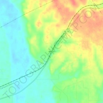
Name: Manila topographic map, elevation, terrain.

Location: Manila, Dallas County, Alabama, United States (32.42847 -86.94110 32.46847 -86.90110)

Average elevation: 55 m

Minimum elevation: 31 m

Maximum elevation: 86 m

Other topographic maps

Click on a map to view its topography, its elevation and its terrain.

Selma

United States > Alabama > Dallas County

Average elevation: 40 m

l

United States > Alabama > Dallas County > Selma

Average elevation: 36 m

Gear up for your next adventure:

🔥Emergency Fire Starter - Reliable ignition source for all weather conditions
🧳Compression Sacks - Maximize space in your backpack by shrinking gear
🧰Multitool Knife - Compact and versatile tool for outdoor use
Backpacking Tent - Lightweight tent for long-distance hiking trips
🥤Collapsible Travel Cup - Saves space and weight in your mess kit

As an Amazon Associate, this site earns from qualifying purchases at no extra cost to you.