Geolocate

Rugby topographic map

Click on the map to display elevation.

About this map

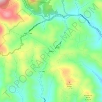
Name: Rugby topographic map, elevation, terrain.

Location: Rugby, Grayson County, Virginia, 24363, United States (36.59068 -81.47066 36.63068 -81.43066)

Average elevation: 986 m

Minimum elevation: 850 m

Maximum elevation: 1,236 m

Other topographic maps

Click on a map to view its topography, its elevation and its terrain.

Independence

United States > Virginia > Grayson County

Average elevation: 817 m

Troutdale

United States > Virginia > Grayson County

Average elevation: 999 m

Fries

United States > Virginia > Grayson County

Average elevation: 710 m

Troutdale

United States > Virginia > Grayson County

Average elevation: 999 m

Independence

United States > Virginia > Grayson County

Average elevation: 817 m

Fries

United States > Virginia > Grayson County

Average elevation: 710 m

Gear up for your next adventure:

🧴Outdoor Sunscreen - High SPF protection for high-altitude UV exposure
🧼Travel Hand Sanitizer - Keep hands clean when water is scarce
🏃Hydration Running Vest - Carry water and maps close to your body for speed
🧴Waterproofing Spray - Restore the DWR coating on jackets and tents
Backpacking Tent - Lightweight tent for long-distance hiking trips

As an Amazon Associate, this site earns from qualifying purchases at no extra cost to you.