
Make a donation
Gear up for your next adventure:
As an Amazon Associate, this site earns from qualifying purchases at no extra cost to you.
Amazon rainforest topographic map
Click on the map to display elevation.
Make a donation
Gear up for your next adventure:
As an Amazon Associate, this site earns from qualifying purchases at no extra cost to you.
About this map
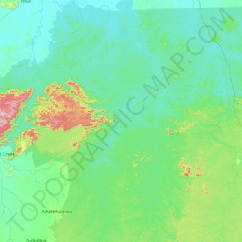
Name: Amazon rainforest topographic map, elevation, terrain.
Location: Amazon rainforest, Guyana (2.46843 -59.49698 3.90855 -58.10941)
Average elevation: 176 m
Minimum elevation: 74 m
Maximum elevation: 994 m
Make a donation
Gear up for your next adventure:
As an Amazon Associate, this site earns from qualifying purchases at no extra cost to you.
Other topographic maps
Click on a map to view its topography, its elevation and its terrain.
Orealla
Guyana > East Berbice-Corentyne > Corentyne River
Orealla (or Orealla Mission) is an Indigenous community in the East Berbice-Corentyne Region of Guyana, on the Courantyne River, approximately 33 miles (53 km) south of Crabwood Creek and 11 miles (18 km) north of Epira, located at 5°17′50″N 57°20′50″W / 5.29722°N 57.34722°W / 5.29722;…
Average elevation: 19 m
Make a donation
Gear up for your next adventure:
As an Amazon Associate, this site earns from qualifying purchases at no extra cost to you.