
Make a donation
Gear up for your next adventure:
As an Amazon Associate, this site earns from qualifying purchases at no extra cost to you.
Linden topographic map
Click on the map to display elevation.
Make a donation
Gear up for your next adventure:
As an Amazon Associate, this site earns from qualifying purchases at no extra cost to you.
Linden
Linden is the second largest city in Guyana after Georgetown, and capital of the Upper Demerara-Berbice region, located at 6°0′0″N 58°18′0″W / 6.00000°N 58.30000°W / 6.00000; -58.30000, altitude 48 m (160 ft). It was declared a town in 1970, and includes the communities of MacKenzie, Christianburg, and Wismar. It lies on the Demerara River and has a population of 27,277 as of 2012. It is primarily a bauxite mining town, containing many mines 60–90 m deep, with many other pits now in disuse. Linden is the regional capital of Upper Demerara-Berbice.
Make a donation
Gear up for your next adventure:
As an Amazon Associate, this site earns from qualifying purchases at no extra cost to you.
About this map
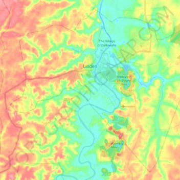
Name: Linden topographic map, elevation, terrain.
Location: Linden, Upper Demerara-Berbice, Guyana (5.89508 -58.39990 6.07270 -58.20412)
Average elevation: 42 m
Minimum elevation: -3 m
Maximum elevation: 93 m
Make a donation
Gear up for your next adventure:
As an Amazon Associate, this site earns from qualifying purchases at no extra cost to you.