
Senapati topographic map
Interactive map
Click on the map to display elevation.
About this map
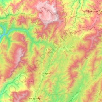
Name: Senapati topographic map, elevation, terrain.
Location: Senapati, Manipur, 795104, Inde (25.16882 93.75872 25.59253 94.30500)
Average elevation: 1,537 m
Minimum elevation: 433 m
Maximum elevation: 2,988 m
Other topographic maps
Click on a map to view its topography, its elevation and its terrain.
Tharon
Inde > Manipur > Tamenglong tehsil
Tharon, Tamenglong tehsil, Tamenglong District, Manipur, Inde
Average elevation: 956 m