Vihren topographic map
Click on the map to display elevation.
Vihren
Vihren (Bulgarian: Вихрен [ˈvixrɛn]) is the highest peak of Bulgaria's Pirin Mountains. Reaching 2,914 metres (9,560 ft), it is Bulgaria's second and the Balkans' third highest, after Musala and Mount Olympus. Although Vihren is deprived of lakes and streams due to the karst topography, a number of Pirin's lakes are located around the peak, as is Europe's southernmost glacial mass, the Snezhnika glacieret. Until 1942 Vihren was known as Eltepe (peak of storms); it was also called Buren (stormy) and Malnienosets (lightning-bringer). The UNESCO World Heritage Site Pirin National Park was originally known as the Vihren National Park. Vihren is included in the 100 Tourist Sites of Bulgaria under No. 2.
About this map
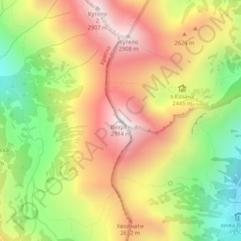
Name: Vihren topographic map, elevation, terrain.
Location: Vihren, без пътека, Bansko, Blagoevgrad, Bulgaria (41.76728 23.39879 41.76738 23.39889)
Average elevation: 2,442 m
Minimum elevation: 1,940 m
Maximum elevation: 2,908 m
Other topographic maps
Click on a map to view its topography, its elevation and its terrain.

Bansko
Bansko lies at the foot of the Pirin Mountains, not far from the national park of the same name, in the valley of the Nestos River at an elevation of 925 meters above sea level. It is a ski resort. The city is about 160 km from Sofia and about 220 km from Thessaloniki.
Average elevation: 1,597 m